
Sir Creek dispute between India and Pakistan explained in detail. Learn about its history, geography, timeline of events, significance for Exclusive Economic Zones (EEZs), fishing rights, and future resolution possibilities.
Introduction
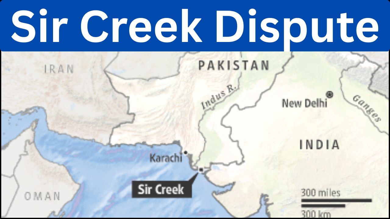
Sir Creek is a 96-kilometer long, narrow, and winding strip of water located in the marshlands of the Rann of Kutch between India and Pakistan. This estuary of the Indus River into the Arabian Sea has remained one of the most debated and unsettled border issues between the two nations since their independence in 1947. Although the dispute appears to be about a creek, its implications extend far beyond geography—it includes questions of sovereignty, fishing rights, marine resources, and exclusive economic zones (EEZs).
Understanding the history, geography, and the timeline of events surrounding Sir Creek provides insights into why this seemingly small area has remained a critical issue in Indo-Pak relations.
India-Pakistan Relations Overview-Smart Bharat Manch
Geography of Sir Creek
Sir Creek lies in the marshy region of the Rann of Kutch, Gujarat, on the Indian side and Sindh, on the Pakistani side. It is a tidal estuary influenced by seasonal monsoons and the flow of the Indus River. During high tide, the area is submerged, while in the dry season, large parts turn into salt flats.
The creek flows into the Arabian Sea, and its significance largely arises because the demarcation of the boundary here affects the extension of maritime boundaries and, consequently, the Exclusive Economic Zone (EEZ). For India, Sir Creek lies in the state of Gujarat, while for Pakistan, it is in Sindh.
Ministry of External Affairs, Government of India
Historical Background
The origin of the Sir Creek dispute can be traced back to the British colonial era. The Bombay Presidency, which governed present-day Gujarat, and the princely state of Kutch signed a resolution in 1914 regarding the boundary with Sindh.
According to the resolution:
- The eastern bank of the creek was considered the boundary.
- However, Pakistan later argued that the boundary should run along the mid-channel of the creek, following the principle of the “Thalweg doctrine,” which is usually applied to navigable rivers.
India maintains that Sir Creek is not a navigable river but a tidal estuary, and thus the 1914 resolution should be followed. This fundamental disagreement forms the core of the dispute.
Timeline of the Sir Creek Dispute
1914
- The Bombay Presidency and the rulers of Kutch sign an agreement marking the eastern bank of Sir Creek as the boundary with Sindh.
1947
- India and Pakistan gain independence. Sir Creek, along with many other borders, becomes part of the new international frontier.
1965
- The Rann of Kutch conflict occurs, leading to military clashes between India and Pakistan over territorial claims.
- The dispute is referred to an international tribunal.
1968
- The Indo-Pakistan Western Boundary Case Tribunal rules in favor of India for about 90% of the Rann of Kutch territory. However, Sir Creek remains unsettled and outside the tribunal’s jurisdiction.
1974
- India and Pakistan sign a maritime agreement, but Sir Creek is excluded from it, leaving the issue unresolved.
1980s–1990s
- Talks between the two countries continue, but no solution is reached. Both sides conduct hydrographic surveys of the region to strengthen their claims.
1999
- The Kargil War further strains Indo-Pak relations, reducing the scope of dialogue on Sir Creek.
2005
- Both countries agree to conduct a joint survey of Sir Creek, raising hopes of a resolution.
2007
- The joint survey is completed, showing that the dispute could be resolved based on scientific data. However, political differences prevent progress.
2008
- The Mumbai terror attacks halt dialogue, and Sir Creek discussions lose priority.
2012
- Reports suggest that Sir Creek was close to resolution before political instability in Pakistan again stalled the process.
Present Day
- The issue remains unresolved. While India insists on the eastern bank as the boundary, Pakistan continues to argue for the mid-channel demarcation.
Strategic and Economic Significance
Exclusive Economic Zones (EEZs)
Under the United Nations Convention on the Law of the Sea (UNCLOS), coastal states have rights over a 200-nautical-mile Exclusive Economic Zone. The resolution of Sir Creek determines how far the maritime boundary extends for both India and Pakistan. A favorable outcome could give each side access to rich fishing grounds and potential offshore oil and gas reserves.
Security Dimension
The marshy terrain of Sir Creek has often been exploited for illegal crossings, smuggling, and infiltration attempts. Both the Indian Border Security Force (BSF) and the Pakistan Rangers patrol the region to prevent illegal activities.
Fishing Rights
The area around Sir Creek is abundant in fish, making it a livelihood source for local fishing communities. Fishermen often stray across the undefined boundary, leading to frequent arrests and diplomatic tensions.
Efforts at Resolution
Despite decades of negotiations, the Sir Creek dispute has resisted settlement. Several rounds of talks, including track-two diplomacy, joint surveys, and expert-level discussions, have taken place. The issue has been considered one of the “easiest to resolve” compared to other India-Pakistan disputes like Kashmir or Siachen, but lack of political trust has prevented closure.
India has consistently argued based on the 1914 resolution, while Pakistan invokes international principles like the Thalweg doctrine. While scientific surveys provide a neutral basis, political considerations dominate the outcome.
Conclusion
The Sir Creek dispute, though geographically small, carries disproportionate strategic and economic weight. Its resolution could unlock new opportunities in marine resources, improve fishing livelihoods, and reduce one more source of conflict between India and Pakistan.
The timeline shows repeated efforts at dialogue, but political tensions have always overshadowed technical agreements. The issue stands as a symbol of how colonial-era decisions continue to shape modern geopolitics.
If India and Pakistan can resolve Sir Creek through mutual dialogue, it could serve as a model of cooperation and confidence-building, paving the way for addressing larger disputes in the subcontinent.
1 thought on “Sir Creek Dispute: History, Geography, and Geopolitical Significance”